
Table of Contents
Scan to BIM converts existing buildings into BIM models. It uses laser scanning and point cloud data. These scans capture accurate building conditions. BIM professionals then create detailed digital models.
- Scan captures existing building conditions digitally.
- Point clouds contain millions of measured points.
- BIM modeling converts point data into elements.
- Applications include renovation, construction, and facility management.
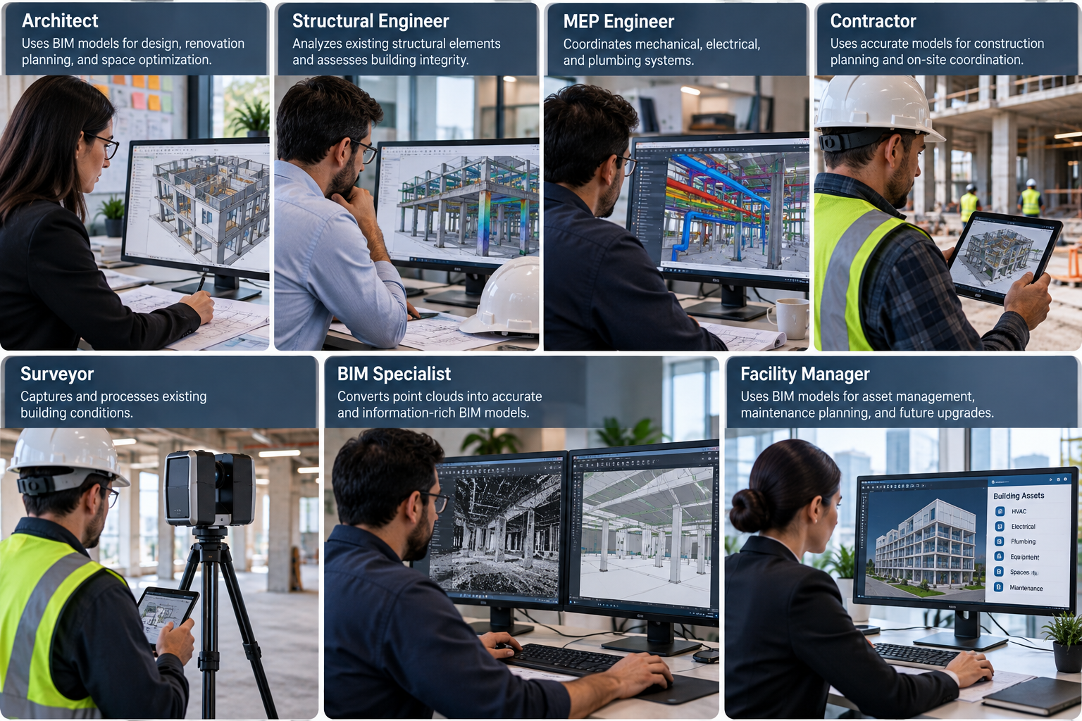
- Users include architects, engineers, contractors, and surveyors.
Scan to BIM is useful for existing buildings. It reduces manual measurement and documentation work. It also improves project accuracy and coordination.
Key Takeaways:
- Scan to BIM converts laser scans into BIM models.
- Point clouds capture accurate existing building conditions.
- It supports renovation, construction, and facility management.
- Scan to BIM offers richer data than Scan to CAD.
- Architects, engineers, contractors, and surveyors use it.
- Beginners can learn it with proper BIM training.
Get Career-Oriented BIM Certification Course with Expert Mentors! Get a free demo here!
What is Scan to BIM?
Scan to BIM is a digital surveying workflow. It combines scanning technology with BIM modeling.
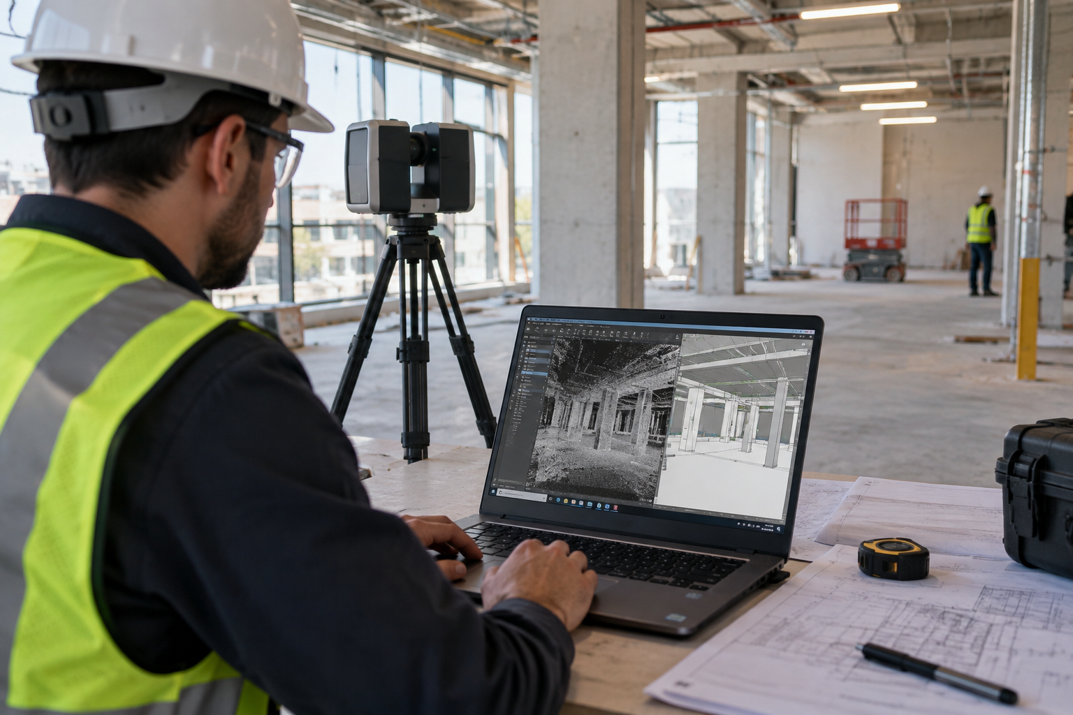
The process begins with capturing existing conditions. Laser scanners collect measurements from the building. These measurements create a detailed point cloud.
The point cloud represents the physical environment digitally. Each point contains precise spatial information. Together, these points show building geometry.
What does Scan to BIM Include?
Scan to BIM can document:
- Walls
- Floors
- Ceilings
- Doors
- Windows
- Structural elements
- Mechanical systems
- Electrical systems
- Plumbing systems
- Building equipment
BIM professionals interpret the captured point cloud. They then create corresponding BIM elements. The final model represents existing site conditions. It can support design and construction decisions.
How is it Different from Regular BIM?
Traditional BIM often starts with design information. Scan to BIM starts with existing physical conditions. This makes it useful for existing structures. It is especially valuable during renovation projects.
Why is Scan to BIM Needed?
Existing buildings rarely match old drawings perfectly. Changes can occur throughout a building’s lifespan. Renovations can add further complexity. Existing drawings may also become outdated.
Scan to BIM captures current site conditions. This provides teams with reliable project information.
Major Reasons to Use Scan to BIM
- Improves measurement accuracy
- Reduces manual surveying
- Captures complex building geometry
- Documents existing conditions
- Supports renovation planning
- Reduces site measurement errors
- Improves design coordination
- Supports clash detection
- Creates accurate as-built information
- Saves repeated site visits
How does it Reduce Project Risks?
Incorrect measurements can create expensive problems. Design teams may rely on outdated drawings. This can cause construction conflicts.
Scan to BIM provides updated spatial information. Teams can identify existing conditions earlier. It also supports better coordination between disciplines. Architects and engineers can use shared models.
Why is it Useful for Renovation?
Renovation projects involve existing structures. Designers must understand current building conditions. Scanning captures difficult areas quickly. It can also document irregular geometry.
This makes planning more reliable. It reduces dependence on manual measurements.
Master BIM and Elevate Your Career – Enroll Today!
Stay ahead in the construction and design industry with our comprehensive BIM Course! Learn Building Information Modeling (BIM) from experts, gain hands-on experience with top software, and boost your career prospects. Join now and become a certified BIM professional!
Know MoreScan to BIM Process: Step-by-Step
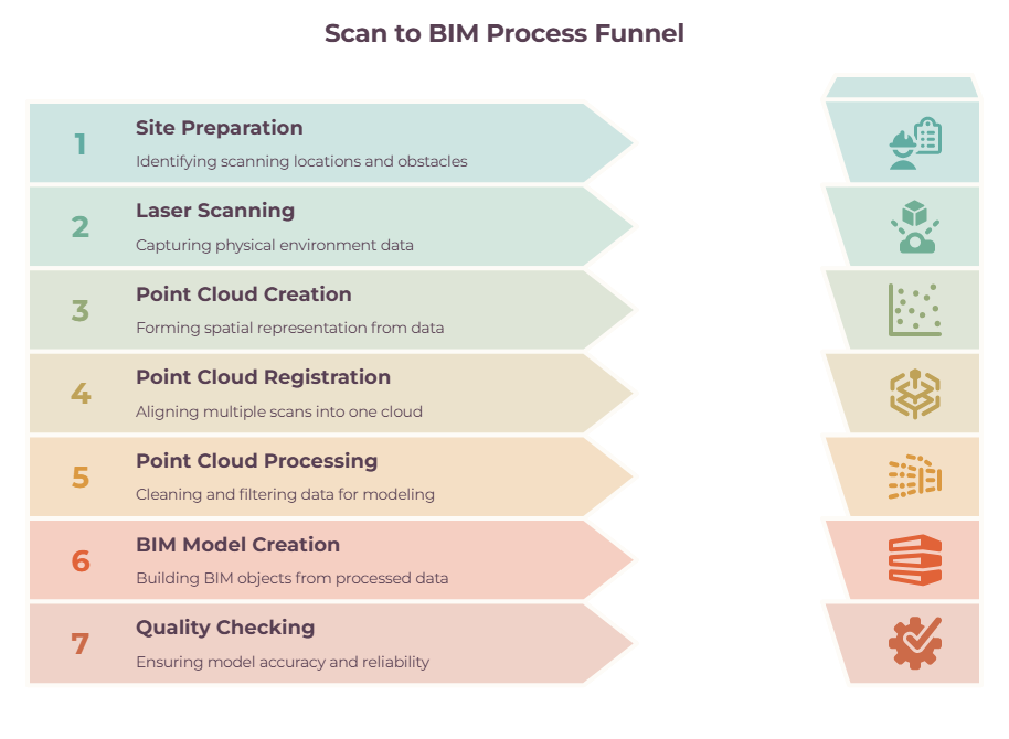
The Scan to BIM process follows several stages. Each stage contributes to model accuracy.
Step 1: Project Planning
The project begins with defining requirements.
Teams identify:
- Project scope
- Building areas
- Required accuracy
- Required model detail
- Required BIM elements
- Delivery format
- Project deadlines
Planning helps determine scanning methods. It also defines the final modeling requirements.
Step 2: Site Preparation
The survey team prepares the building. They identify accessible scanning locations. They also review potential obstacles. Moving objects may affect scanning results.
Teams may establish scanning positions beforehand. This helps achieve complete coverage.
Step 3: Laser Scanning
Laser scanners capture the physical environment. The scanner sends laser pulses around the space. These pulses measure distances from surfaces. The scanner records millions of measurements.
Multiple scanner positions may be necessary. This captures hidden and complex areas.
Step 4: Point Cloud Creation
Collected measurements become point cloud data. The cloud contains millions of individual points. Each point represents a measured location. Together, points create a spatial representation.
Point clouds can show:
- Building surfaces
- Structural elements
- Equipment
- Pipes
- Ducts
- Architectural details
Step 5: Point Cloud Registration
Multiple scans need alignment. Registration combines individual scans together. The result becomes one coordinated point cloud. Accurate registration is essential for modeling.
Survey teams check alignment errors carefully. Poor registration can affect the final model.
Step 6: Point Cloud Processing
Raw point clouds require additional processing. Unnecessary data may be removed.
Teams can filter:
- Noise
- Unwanted objects
- Temporary equipment
- Duplicate points
- Irrelevant areas
The cleaned cloud becomes easier to use. It also supports efficient BIM modeling.
Step 7: BIM Model Creation
BIM specialists begin modeling from the point cloud. They identify building components within the data.
These components become BIM objects.
Examples include:
- Walls
- Columns
- Beams
- Slabs
- Doors
- Windows
- Pipes
- Ducts
- Equipment
Modelers follow the required level of detail. They also follow project modeling standards.
Step 8: Quality Checking
The model undergoes detailed quality checks. Teams compare models against point clouds.
They look for:
- Missing elements
- Incorrect dimensions
- Modeling errors
- Alignment issues
- Unmodeled components
- Incorrect element placement
Quality control improves model reliability.
Step 9: Final Model Delivery
The completed BIM model is delivered. The format depends on project requirements.
The model can support:
- Design development
- Construction planning
- Renovation
- Coordination
- Facility management
- As-built documentation
What Technologies are Used in Scan to BIM?
Scan to BIM combines several technologies. Each technology supports a specific workflow stage.
1. LiDAR
LiDAR uses laser technology for measurements. It can capture large areas efficiently.
LiDAR systems provide detailed spatial information. They are widely used for surveying applications.
2. Terrestrial Laser Scanners
These scanners operate from fixed positions. They capture detailed building measurements.
They work well for:
- Buildings
- Interiors
- Structural surveys
- Industrial facilities
- Large spaces
3. Mobile Scanning
Mobile scanners collect data while moving. They can cover large areas efficiently.
These scanners are useful for complex environments. They can also reduce scanning time.
4. Photogrammetry
Photogrammetry uses photographs for spatial reconstruction. Multiple images create three-dimensional information.
It can complement laser scanning workflows. It can also capture visual building information.
5. Point Cloud Software
Specialized software processes scanning data. It supports registration, cleaning, and visualization.
These tools prepare data for BIM modeling.
6. BIM Software
BIM software converts point clouds into models. Modelers create intelligent building elements.
The chosen software depends on project requirements. Different platforms support different BIM workflows.
Scan to BIM vs Traditional Building Surveying
Both methods document existing building conditions. However, their workflows are significantly different.
| Factor | Scan to BIM | Traditional Surveying |
|---|---|---|
| Data Collection | Laser scanning | Manual measurements |
| Output | BIM model and point cloud | Measurements and drawings |
| Speed | Generally faster | Can take longer |
| Accuracy | High spatial accuracy | Depends on survey methods |
| Complex Geometry | Captures efficiently | More difficult manually |
| Digital Workflow | Highly integrated | Often requires extra processing |
| Repeated Visits | Can reduce visits | May require more visits |
| Project Use | BIM coordination and planning | Basic documentation |
When is Scan to BIM Better?
Scan to BIM works well for complex buildings. It also suits large renovation projects.
Scan to BIM is useful when teams need accurate digital models. It can also support multiple project disciplines.
When can Traditional Surveying Work?
Traditional surveying may suit smaller projects. It can also work for simple measurements.
Simple spaces may not require extensive scanning. Project requirements should determine the approach.
Master BIM and Elevate Your Career – Enroll Today!
Stay ahead in the construction and design industry with our comprehensive BIM Course! Learn Building Information Modeling (BIM) from experts, gain hands-on experience with top software, and boost your career prospects. Join now and become a certified BIM professional!
Know MoreFrequently Asked Questions
What is Scan to BIM in simple terms?
Scan to BIM converts scanned building data into a BIM model. It helps create an accurate digital representation of an existing building.
How does Scan to BIM work?
The process starts by scanning the existing building. The resulting point cloud is then processed and converted into a BIM model.
What is a point cloud in Scan to BIM?
A point cloud contains millions of measured points from scanned surfaces. These points represent the building’s geometry and existing conditions.
Is Scan to BIM the same as BIM?
No, Scan to BIM is a specific BIM creation process. It uses real-world scanning data to create models of existing buildings.
What software is used for Scan to BIM?
Scan to BIM workflows use scanning, point cloud, and BIM software. The software choice depends on project requirements and modeling needs.
What is the difference between Scan to BIM and Scan to CAD?
Scan to BIM creates information-rich three-dimensional models. Scan to CAD generally converts scan data into conventional CAD drawings.
How accurate is a Scan to BIM model?
Accuracy depends on scanning equipment, site conditions, and processing methods. Model accuracy also depends on the required level of detail.
How much does Scan to BIM cost?
Scan to BIM costs vary based on building size and project complexity. Scanning requirements, model detail, and project scope also affect the overall cost.
What industries use Scan to BIM?
Construction, architecture, engineering, and facility management commonly use Scan to BIM. It is also useful for renovation, infrastructure, and heritage projects.
Can beginners learn Scan to BIM?
Yes, beginners can learn Scan to BIM with proper training and practice. Basic BIM knowledge, point cloud understanding, and modeling skills provide a useful foundation.